Earth and Environmental Sciences Area Logo Earth and Environmental Sciences Area Logo
Lawrence Berkeley National Laboratory Logo
Menu
  • About Us
    • Contact Us
    • Organizational Charts
    • Virtual Tours
    • EESA Strategic Vision
  • Our People
    • A-Z People
    • Alumni Network
    • Area Offices
    • Committees
    • Directors
    • IDEA Working Group
    • Paul A. Witherspoon
    • Postdocs & Early Careers
    • Search by Expertise
  • Careers & Opportunities
    • Careers
    • Intern Pilot w/CSUEB
    • Mentorship Program
    • Recognition & Funding Opps
    • EESA Mini Grants
    • S&E Metrics for Performance and Promotion
    • Student Opportunities
    • Supervisor EnRichment (SupER) Program
    • Promotion Metrics (Scientific)
  • Research
    • Area-Wide Program Domain
      • Earth AI & Data
    • Our Divisions
    • Climate & Ecosystem Sciences Division
      • Environmental & Biological Systems Science
        • Programs
        • Environmental Remediation & Water Resources
        • Ecosystems Biology Program
        • Bioenergy
      • Biosphere-Atmosphere Interactions
        • Programs
        • Climate Modeling
        • Atmospheric System Research
        • Terrestrial Ecosystem Science
      • Climate & Atmosphere Processes
        • Programs
        • Climate Modeling
        • Atmospheric System Research
      • Earth Systems & Society
        • Programs
        • Climate Modeling
    • Energy Geosciences Division
      • Discovery Geosciences
        • Programs
        • Basic Energy Sciences (BES) Geophysics
        • Basic Energy Sciences (BES) Geochemistry
        • Basic Energy Sciences (BES) Isotope
      • Energy Resources and Carbon Management
        • Programs
        • Carbon Removal & Mineralization Program
        • Carbon Storage Program
        • Geothermal Systems
        • Hydrocarbon Science
        • Nuclear Energy & Waste
      • Resilient Energy, Water & Infrastructure
        • Programs
        • Water-Energy
        • Critical Infrastructure
        • Environmental Resilience
        • Grid-Scale Subsurface Energy Storage
        • National Alliance for Water Innovation (NAWI)
    • Projects
    • Research at a Glance
    • Publication Lists
    • Centers and Resources
    • Technologies & National User Programs
  • Departments
    • Climate Sciences
    • Ecology
    • Geochemistry
    • Geophysics
    • Hydrogeology
    • Operations
  • News & Events
    • News
    • Events
    • Earth & Environment Newsletter
  • Intranet
  • Safety
    • EESA Safety
  • FoW
  • Search

  • all
  • people
  • events
  • posts
  • pages
  • projects
  • publications

New Research Demonstrates Method for Rapidly Characterizing Watershed Organization and Function Using Zone-based Approach3 min read

by Julie Bobyock on March 16, 2022

Climate and Ecosystem Sciences Division

Above: The East River Watershed Research site located near the headwaters of the Colorado River — is the focus of research by the DOE Watershed Function SFA led by Berkeley Lab. A recent paper describes the researchers efforts to develop a watershed zonation approach – a method that uses unsupervised machine learning to characterize entire watersheds by identifying zones of similar functioning and characteristics.

More than half of earth’s freshwater comes from mountainous watersheds – areas of land that catch precipitation and drain to nearby streams, lakes, and rivers. These ecosystems provide services such as water filtration, nutrient cycling and carbon storage that can significantly impact the amount of clean, freshwater critical for energy production, agriculture, and municipal water supply.

Now that disturbances such as drought, wildfires, and floods mark what many consider the “new normal,” practitioners can no longer depend on historical trends to project how watersheds will behave in future years or decades. Instead, new ways to study watershed response to environmental changes are needed. However, watershed behavior is difficult to predict in part because areas within the same watershed can be very diverse. For example, one zone in a watershed may be exposed to different meteorological conditions, support very different plants, and have different soil and geology compared to an adjacent area. This variability occurs over multiple scales and elevations, posing challenges to studying how watersheds function holistically.

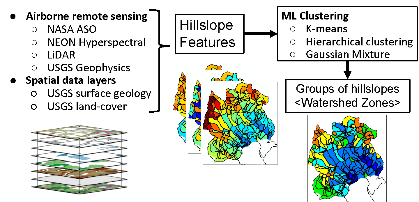
To characterize the heterogeneous bedrock-to-canopy compartments and their impacts of watershed function, the Watershed Function Scientific Focus Area led by Berkeley Lab used data from a mountainous headwater catchment in the Upper Colorado River Basin to develop a watershed zonation approach – a method that uses unsupervised machine learning to characterize entire watersheds by identifying  zones of similar functioning and characteristics. A recent paper describes their new method. 

Above: The watershed zonation method applies unsupervised clustering to various spatial data layers for grouping hillslopes with similar above and below-ground environmental features.

According to the lead author Haruko Wainwright, these “functional” zones, or watershed “zipcodes,” are expected to have a characteristic response to a perturbation. One functional zone might be conifer-dominated, north-facing hillside on granitic bedrock, while another could be south-facing meadow-dominated on shale bedrock. “These different zones are likely to respond uniquely to a perturbation such as early snowmelt or drought, and contribute a unique signature to the downgradient integrated water discharge and water-quality signature”, says Wainwright.

Co-author Susan Hubbard, former EESA Associate Lab Director and former lead for the Watershed Function SFA project, described the significance of this method. “Key watershed ‘data layers’ – which provide information about bedrock-through-canopy properties such as nutrient levels, water storage in soil, and temperature – are becoming more available using satellites and drones. This study shows how these data layers can be used to create 3D models, or ‘digital twins’ of complex watersheds.”

Wainwright explains that, “the study also shows how machine learning can be used with the data layers to identify watershed zonation, or watershed structure. This enables investigation of how the distinct zones respond to abrupt and gradual disturbances. Not only will the new zone-based approach help to address a longstanding watershed science question of ‘how much is enough’ when it comes to characterization datasets, but it will also allow for optimization of costly field campaigns and improve numerical prediction of how the watershed behaves as an aggregation of zones.”

As environmental disturbances occur more frequently and water demand continues to increase, the watershed zonation method allows for more accurate predictions of how watersheds will function in order to monitor and protect freshwater quality and quantity.

News & Events

Study Sheds Light on Microbial Communities in Earth’s Subsurface2 min read

August 16, 2023

  From the tops of tree canopies to the bottom of groundwater reservoirs, a vast amount of living organisms interact with nonliving components such as rock, water, and soil to shape this area of Earth known as the “critical zone.” Over half of Earth’s microbes are located in the subsurface critical zone, which ranges from…

Carl Steefel Honored in Goldschmidt Session on Reactive Transport2 min read

August 2, 2023

The contributions of Carl Steefel to the reactive transport modeling scientific community were recognized in a session held in his honor at the recent Goldschmidt 2023 conference (Lyon, France). Goldschmidt is the foremost annual, international conference on geochemistry and related subjects, organized by the European Association of Geochemistry and the Geochemical Society. The session was…

DOE Funds Projects to Advance Forest Carbon Dioxide Removal Efforts and Agricultural Soil Carbon Conservation4 min read

August 1, 2023

The DOE Office of Fossil Energy and Carbon Management (FECM) and Office of Technology Transitions (OTT) recently announced $5 million in funding for four projects–two from Berkeley Lab with EESA leadership. The projects selected offer “promising solutions” to the nation’s climate change challenges by helping to reduce greenhouse gas emissions and will “accelerate their deployment…

Quantifying the strength of the land carbon sink3 min read

July 26, 2023

This article first appeared at nature.berkeley.edu/news. The world’s forests, grasslands, and other terrestrial ecosystems have played a substantial role in offsetting human carbon emissions—a capability that UC Berkeley researchers say would be threatened by continued global change. The assessment, published today as a new review paper in Nature Reviews Earth & Environment, presents a comprehensive analysis of…

  • Our People
    • Area Offices
    • Committees
    • Directors
    • Organizational Charts
    • Postdocs
    • Staff Only
    • Search by Expertise
  • Departments
    • Climate Sciences
    • Ecology
    • Geochemistry
    • Geophysics
    • Hydrogeology
  • Research
    • Climate & Ecosystem Sciences Division
    • Energy Geosciences Division
    • Program Domains
      • Programs
    • Projects
  • Contact
    • 510 486 6455
    • eesawebmaster@lbl.gov
    • Our Identity

Earth and Environmental Sciences Area Logo DOE Earth and Environmental Sciences Area Logo UC

A U.S. Department of Energy National Laboratory Managed by the University of California

Lawrence Berkeley National Laboratory · Earth and Environmental Sciences Area · Privacy & Security Notice