Earth and Environmental Sciences Area Logo Earth and Environmental Sciences Area Logo
Lawrence Berkeley National Laboratory Logo
Menu
  • About Us
    • Contact Us
    • Organizational Charts
    • Virtual Tours
    • EESA Strategic Vision
  • Our People
    • A-Z People
    • Alumni Network
    • Area Offices
    • Committees
    • Directors
    • IDEA Working Group
    • Paul A. Witherspoon
    • Postdocs & Early Careers
    • Search by Expertise
  • Careers & Opportunities
    • Careers
    • Intern Pilot w/CSUEB
    • Mentorship Program
    • Recognition & Funding Opps
    • EESA Mini Grants
    • S&E Metrics for Performance and Promotion
    • Student Opportunities
    • Supervisor EnRichment (SupER) Program
    • Promotion Metrics (Scientific)
  • Research
    • Area-Wide Program Domain
      • Earth AI & Data
    • Our Divisions
    • Climate & Ecosystem Sciences Division
      • Environmental & Biological Systems Science
        • Programs
        • Environmental Remediation & Water Resources
        • Ecosystems Biology Program
        • Bioenergy
      • Biosphere-Atmosphere Interactions
        • Programs
        • Climate Modeling
        • Atmospheric System Research
        • Terrestrial Ecosystem Science
      • Climate & Atmosphere Processes
        • Programs
        • Climate Modeling
        • Atmospheric System Research
      • Earth Systems & Society
        • Programs
        • Climate Modeling
    • Energy Geosciences Division
      • Discovery Geosciences
        • Programs
        • Basic Energy Sciences (BES) Geophysics
        • Basic Energy Sciences (BES) Geochemistry
        • Basic Energy Sciences (BES) Isotope
      • Energy Resources and Carbon Management
        • Programs
        • Carbon Removal & Mineralization Program
        • Carbon Storage Program
        • Geothermal Systems
        • Hydrocarbon Science
        • Nuclear Energy & Waste
      • Resilient Energy, Water & Infrastructure
        • Programs
        • Water-Energy
        • Critical Infrastructure
        • Environmental Resilience
        • Grid-Scale Subsurface Energy Storage
        • National Alliance for Water Innovation (NAWI)
    • Projects
    • Research at a Glance
    • Publication Lists
    • Centers and Resources
    • Technologies & National User Programs
  • Departments
    • Climate Sciences
    • Ecology
    • Geochemistry
    • Geophysics
    • Hydrogeology
    • Operations
  • News & Events
    • News
    • Events
    • Earth & Environment Newsletter
  • Intranet
  • Safety
    • EESA Safety
  • FoW
  • Search

  • all
  • people
  • events
  • posts
  • pages
  • projects
  • publications

EESA Geophysicists Explore Landslide Hazard Using Novel Remote-Sensing Approach3 min read

by Christina Procopiou on October 17, 2022

Energy Geosciences Division

Above: EESA geophysicists are using sensors capable of remotely monitoring land deformation and soil characteristics like cohesion and thickness that are indicative of the potential for landslide hazard. When paired with machine learning, the data could help scientists predict the probability of a shallow landslide–usually less than 3 meters–at different points across a landscape at different times. Photo by Sebastian Uhlemann

Torrential rains in Venezuela early last week provoked a devastating landslide, adding to the deluge of stunning climatic events of the past month. With locations around the globe receiving larger amounts of intense rainfall over shorter periods of time under climate change, bigger, costlier landslides that directly impact infrastructure have become more frequent–and urbanization exacerbates their risk.

Landslides are the downslope movements of soil or rock, and shallow slides which are typically less than 3m deep affecting just the soil can be plenty disruptive. EESA geophysicists are testing out using low-cost, low-profile sensors to monitor shallow landslide processes and learn which characteristics increase landslide hazard. What they find could equip land managers with the tools needed to map landslide hazards across space and time or ultimately to develop landslide early-warning methods. 

EESA Scientists Sebastian Uhlemann, Stijn Wielandt, and Baptiste Dafflon and Postdoc Fellow Sylvain Fiolleau are using novel geophysical and remote-sensing techniques to estimate soil conditions such as soil cohesion and thickness, which dictate how much material can move downslope, as well as signs of ambient seismic noise, which are known to change their characteristics hours before a landslide occurs.

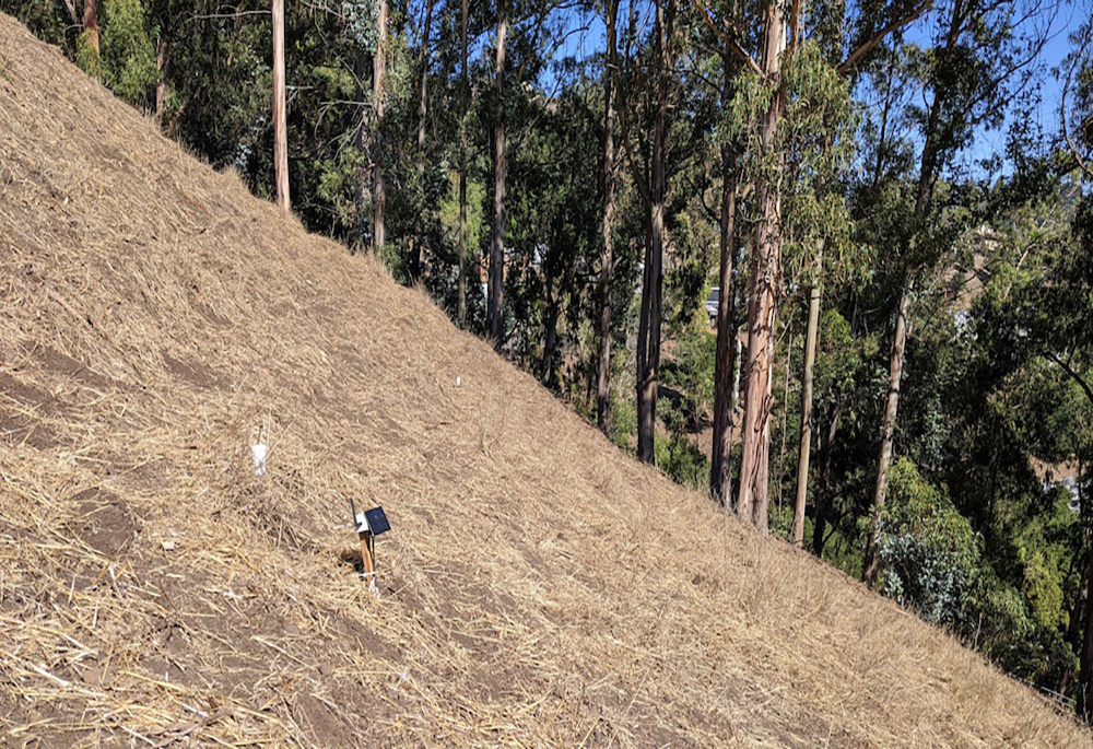
“The traditional approach to mapping landslide hazards is building ground models to depict Earth’s subsurface. These take considerable effort involving drilling, which can be complicated due to steep slopes and limited access, and analyzing soil samples, which is costly and slow,” said Uhlemann. “We have shown that we are able to characterize the subsurface with considerably less effort using geophysical and remote-sensing data to estimate critical parameters, such as soil cohesion, in different locations across our study site. To monitor the soil parameters that are important for landslide processes, we developed low-profile sensors that are easy to install and inexpensive.”

This work is similar to other efforts underway by EESA scientists who are using novel sensing tools and computer modeling to assess, for example, how climate change is impacting a vast Colorado River watershed or to speed up the time it takes to evaluate whether critical buildings are safe to occupy shortly after a major earthquake. In the case of the work led by Uhlemann, it’s possible to take the data obtained by the sensors and establish a landslide probability map estimating the degree of landslide hazard at different locations across a site, or to focus more narrowly on particular areas of concern. The team is also experimenting with using machine learning to predict future changes in soil properties that could potentially alter the degree of landslide hazard and allow them to assess risk hours to days ahead of time. This will then enable early warning of potentially hazardous conditions. 

Between 2004 and 2016, 4,862 nonseismic fatal landslide events were recorded in the Global Fatal Landslide Database–12% of these events directly impacted infrastructure. Research into improving efforts to quantify landslide hazard and risk are needed as the number and intensity of these events continue to rise. This work is supported by Berkeley Lab’s Laboratory Directed Research and Development Program.

A recent paper, “Low-Power, Flexible Sensor Arrays with Solderless Board-to-Board Connectors for Monitoring Soil Deformation and Temperature,” was published this spring in the journal Sensors and describes the team’s work. 


News & Events

Former Intern Emily Nagamoto Wins AGU Award1 min read

March 27, 2023

Former Science Undergraduate Laboratory Intern (SULI) Emily Nagamoto received an American Geophysical Union (AGU) Outstanding Presentation Award, which honors exceptional presentations given during AGU’s 2022 Fall meeting. She was mentored by Staff Scientist Charuleka Varadharajan and Postdoctoral Research Fellow Mohammed Ombadi during her Summer 2022 SULI term. Currently an undergraduate student in Duke University’s Nicholas…

EESA Scientists Investigate How Tropical Soil Microbes Might Respond to Future Droughts2 min read

March 14, 2023

As the most biologically diverse terrestrial ecosystems on Earth, tropical rainforests are just as critical to sustaining environmental and human systems as they are beautiful. Their unique climate with high temperatures, humidity, and precipitation promotes high primary productivity, which offsets high respiration, resulting in these ecosystems being one of the largest carbon sinks on Earth,…

Doubling Protected Lands for Biodiversity Could Require Tradeoffs With Other Land Uses, Study Finds4 min read

March 3, 2023

This article first appeared on lbl.gov. Scientists show how 30% protected land targets may not safeguard biodiversity hotspots and may negatively affect other sectors – and how data and analysis can support effective conservation and land use planning Although more than half the world’s countries have committed to protecting at least 30% of land and oceans…

Six Berkeley Lab Scientists Named AAAS Fellows6 min read

This article first appeared at lbl.gov Six researchers have been elected into the 2022 class of the American Association for the Advancement of Science The American Association for the Advancement of Science (AAAS) has announced their 2022 Fellows, including six scientists from the Department of Energy’s Lawrence Berkeley National Laboratory (Berkeley Lab). This lifetime honor, which follows…

  • Our People
    • Area Offices
    • Committees
    • Directors
    • Organizational Charts
    • Postdocs
    • Staff Only
    • Search by Expertise
  • Departments
    • Climate Sciences
    • Ecology
    • Geochemistry
    • Geophysics
    • Hydrogeology
  • Research
    • Climate & Ecosystem Sciences Division
    • Energy Geosciences Division
    • Program Domains
      • Programs
    • Projects
  • Contact
    • 510 486 6455
    • eesawebmaster@lbl.gov
    • Our Identity

Earth and Environmental Sciences Area Logo DOE Earth and Environmental Sciences Area Logo UC

A U.S. Department of Energy National Laboratory Managed by the University of California

Lawrence Berkeley National Laboratory · Earth and Environmental Sciences Area · Privacy & Security Notice